
The problem was that I couldn’t track down any information about it. The volcano is actually in Chile so none of my Argentine friends could tell me much about the terrain. I figured I could hire a guide, but the eruption had killed tourism in the region so most guides had moved out in search of work elsewhere. Finally, I decided to just rent a car, drive towards the volcano, and hope something would work out.
This plan worked out remarkably well. Half a mile into Chile, I pulled over at a lodge in Anticura and discovered the guy running the place, Christian, happened to be a mountain guide. I asked Christian where I could find a map, but he laughed at me and asked, “Tell me, for what reason do you need a map? ” He followed this with “There is nothing dangerous in Chile” and “Everything in Chile is very easy. You will not get lost.” This is not what I wanted to hear. I had been led astray by overeager mountain guides on my previous trip to Patagonia so I was pretty skeptical of Christian. But with no other option, I stocked up on supplies and headed out with his hand-drawn map as my guide.

A German-style cabin at the Anticura lodge. Many Germans settled in Chile during the mid-20th century.
I was headed for Volcan Casablanca, a dormant volcano 15 miles south of Puyehue. Using the 3D terrain feature in Google Earth, I figured it would give me a good vantage point of the ash column. Amazingly, the route was exactly as easy as Christian had claimed. The road takes you to a crater a few thousand feet below the summit. From there, you simply pick a line and walk up the mountain.
I had this vision of flying my kite rig above the Casablanca crater and showing Puyehue’s ash column rising up in the distance. I got to the summit with an hour of daylight left, but I was on the wrong side of the crater to get the image I wanted. I scrambled to get into position and in a desperate move, launched my kite in the sketchiest conditions I have ever attempted. Until this point, I had only flown my kite in open, grassy plains. In these cases, if the wind got too strong, I could tie off the line and walk the camera down. If the wind slackened, I could run backwards to keep the camera from falling out of the sky. Standing on the lip of a volcanic crater with cliffs on either side of me, I had neither of those options. Moving along the rim required carefully crawling on all fours so that didn’t give offer me any maneuverability either. Even if I could find somewhere to tie off the line, the jagged rock would sever it immediately. If the wind wasn’t just right, I would either watch my camera plummet into the crater or be forced to let go of the line so that I wouldn’t fall in myself. Maybe not the best judgment call on my part.

A photo I took of Puyehue as I hiked up Volcan Casablanca. Puyehue is the peak to the right of the ash column. It is not erupting, rather a crack in the Puyehue Cordon-Caulle volcanic complex is producing the ash.
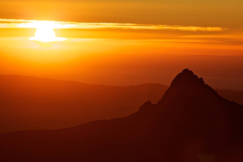
Thing is, I am at this stage in my life where I am really interested in exploring exactly how much I can get away with. There is something fascinating about figuring out where that limit is. Ok, maybe I’ve been at that stage for the last 25 years, but the important thing is the wind happened to be just perfect that day. Too bad the picture I was after turned out to be totally boring. I gave up on photographing the volcano and settled for shooting the sunset instead.

A kite aerial view of the eruption didn't work out, so I photographed the sunset instead. I am standing on the east rim of Casablanca's summit, looking across the crater. The smooth surface you see in the foreground is ash-covered snow.
The ash in the air makes for spectacular sunsets
Plan A had failed and I had no plan B, so what now? Dejected, I wandered back to my makeshift camp and plopped down to watch the last rays of sunlight slip over the horizon. Half-heartedly, I pulled out my 300mm and shot the ash column, but who was I kidding? Just more lame pictures of the eruption. Then I saw it. A tiny spark. Then another. Barely visible specks of red flashing in the distance. Is that…lava? Holy SHIT there’s LAVA!!!!! Plan B suddenly fell into place. Tight nightscape shot with a long exposure to get the lava to light the ash from below and star trails in the background. Maybe even some moonlight to give the surrounding ridges some texture. YESSS!!! I just couldn’t see it before because the lava wasn’t visible in daylight. All I needed was my timer remote for this to work. The timer remote that I had left in the car to save 2oz. of weight. Dammit. Well, at least now I had a plan.

Telephoto shot of the ash column. I wasn't thrilled about this photo, but it was the best I could come up with for the time being.
I spent the next day retrieving my remote only to discover the clouds had moved in to obscure my view entirely. The sky cleared up some time around 2am so I managed to get a few frames, but again, it wasn’t as impressive as I had hoped. I was onto something though. With a little more moonlight I could cut the shutter speed and get better definition in the ash column. I just needed a few more nights to figure this out.

Long exposure of the lava at night. Definitely showed potential, but this still wasn't the frame I was looking for.

My camp at the summit of Casablanca. The wind was so strong that it would punch the tent ceiling down onto my face until I finally just pulled the poles out and slept in the flattened tent.

While I wasn't directly downwind of the eruption, the wind was kicking up enough ash to make my teeth feel crunchy. So I decided to sleep with a respirator on. I didn't bring a pad so I slept on top of my kites instead.
No comments:
Post a Comment